

The following article was written by Michael Fagin. Fagin is an operational meteorologist providing weather forecasts to clients in the Pacific Northwest and providing custom forecast for groups climbing Mt. Everest and other major peaks. Fagin is also a travel writer with a focus on weather and wine.
All forecasts over the last several months have consistently indicated that we will have an El Niño event this fall and winter. El Niño is above average sea surface temperatures off the equatorial waters of South America. In contrast, La Niña is below average sea surface temperatures off the equatorial waters of South America
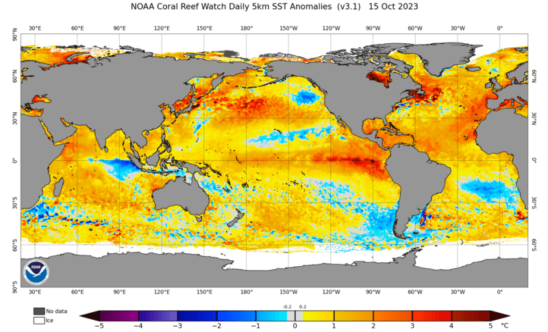
In assessing El Niño probability, meteorologists look at sea surface temperature anomalies, focusing between 170 degrees west to 120 west longitude. The map below indicates those temperatures are currently in the range of 1 to 2 degrees Celsius above average.
A weak El Niño is considered to be between 0.50 to 0.90 degrees Celsius, moderate 1.0 to 1.4, strong 1.5 to 1.9, and very strong over 2. The strength of the El Niño will often dictate weather conditions or tendencies. At present, we are in a strong phase, with 1.5 C above average as shown in the graphic below. Many experts suggest that this will continue to increase. We will discuss what the impacts of this might be on weather conditions on the west coast in general and, more specifically, Oregon and Washington.
Typical El Niño winter conditions for the West Coast
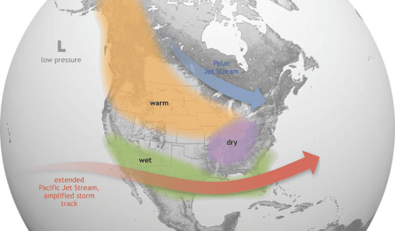
In a typical El Niño, as the map below shows, the jet stream and associated wet weather systems are aimed into California and more frequently into Southern California during the winter. Thus, that region will tend to have above-average rainfall and above-average snowpack. With this pattern, the Pacific Northwest will often have below-average precipitation, above-normal temperatures, and below-average snowfall.
What factors Impact El Niño? It’s Complicated!
Some meteorologists are asking what the impacts on El Niño will be from the warm ocean temperatures recorded this summer and fall in most ocean basins. Many think this will make the current El Niño season stronger.
However, the Pacific Decadal Oscillation (PDO), which is the long-term fluctuation of temperatures in the Pacific Ocean, is currently negative. This is considered the cool phase and tends to bring cooler temperatures to the Pacific Northwest.
How will this impact El Niño? There really is not enough data to reach any conclusions about the impact of PDO. PDO and warm ocean temperatures are just two meteorological factors that can impact El Nino. There are more.
Recent El Niño Events
Given the present scenario, we are likely looking at a moderate to strong El Niño for this upcoming season. Let us look at prior events and see how this impacted mountain snowfall. Mountain snowfall and the snowmelt during the spring and summer are critical for irrigation to vineyards.
The map below is calculated from 15 moderate to strong El Niño events dating back to the 1940-41 winter season. The dark brown color is under 50% of normal snowfall for the Puget Sound, Willamette Valley, as well as parts of the Columbia Basin. Much of the Washington and Oregon Cascades are also under 50% average, although some parts have yellow colors, which is 75 to 95% of average.
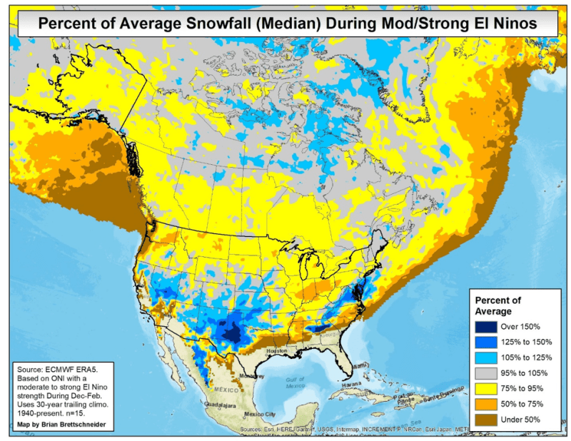
The map above was created by Meteorologist Brian Brettschneider.
To look at the Washington Cascades to see what happened during the last five strong El Niño events, I looked at snow on the ground in April (often called snowpack) for Stevens Pass and Paradise at Mt. Rainier. These locations had three years below average snowpack and two years average snowpack. For Oregon, we get a different picture when looking at the Mt. Hood area. Three of the five years were above average. However, in the two years that were below average, it was 55% and 26% of average.
Very strong El Niño events
What do the historical data show when we have a very strong El Niño? I looked at three events for Stevens Pass and Paradise. All three events at Stevens had a below-normal snowpack and for Paradise one was average, one above, and one below average. For Mount Hood one was above average and two were below average. Thus for a very strong El Niño, the odds seem tilted toward below-average snowpack in these areas. (The last very strong El Niño was 2015-2016.)
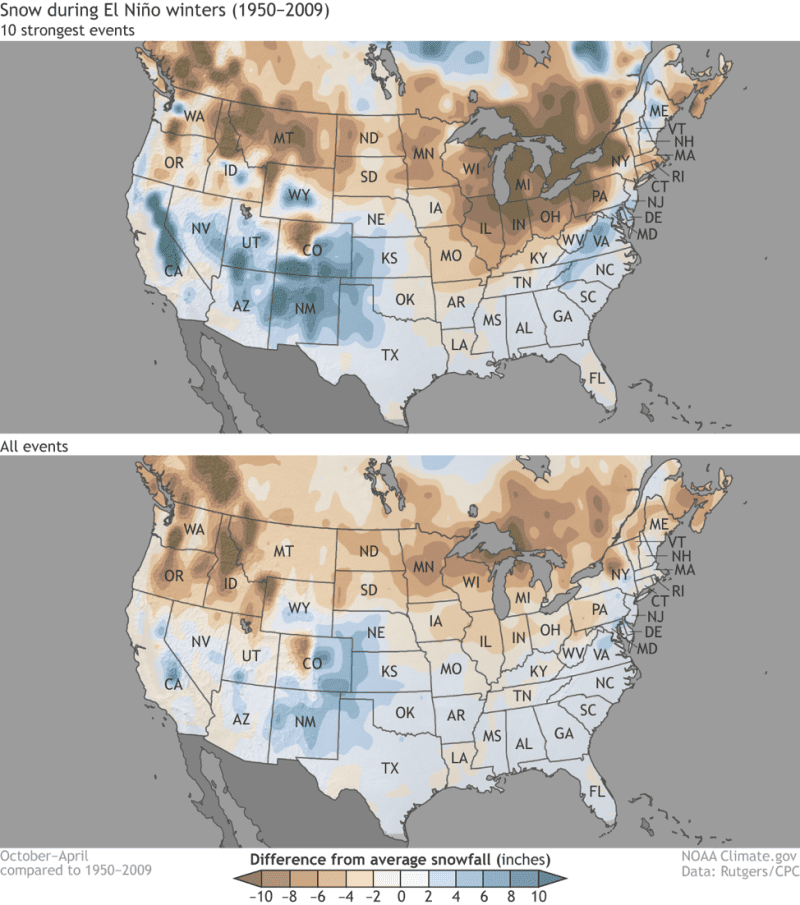
Looking at all El Niño events and all strong El Niño events that meteorologist Cliff Mass prepared, much of Washington and Oregon snowfall is below average. This is shown as the darker brown color below, which represents approximately 8 to 10 inches below average snowfall.
In summary, past data indicate that a moderate to strong El Niño will generally tilt the odds of the Pacific Northwest toward having below-average mountain snow. However, some seasons have average to above-average snow. It is difficult to predict.
Winter Outlook 2023-2024
What can we expect for the upcoming winter? Before we look at that, one thing to be aware of is the shortcomings of these seasonal outlooks since we are looking at 90 days+ in the extended period. Some recent seasonal forecasts have had some shortcomings in the accuracy of these outlooks. However, there can be some improved accuracy when there is a strong El Niño. Let’s look at what the Climate Prediction Center and European Model Forecast say.
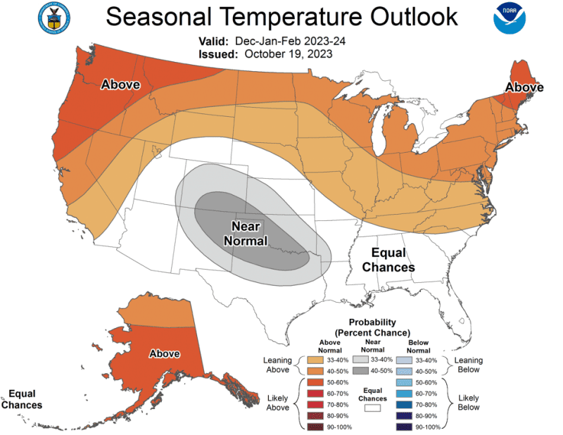
Climate Prediction Center
The November, December, January 2023-2024 temperature outlook favors above-normal temperatures for Alaska, the Far West, the northern tier of the contiguous U.S. as well as for the Ohio Valley and mid-Atlantic. The greatest likelihood for warmer than normal temperatures is for parts of Alaska, the Pacific Northwest, and New England. There is high likelihood for the continuation of a strong El Niño event through Spring 2024
In terms of precipitation, above-normal seasonal precipitation amounts are most likely for the north slope of Alaska, the southern Plains, lower Mississippi valley, Southeast and southern mid-Atlantic. Drier-than-normal conditions are most likely for areas in the Pacific Northwest, northern Rockies, northern High Plains and parts of Michigan.
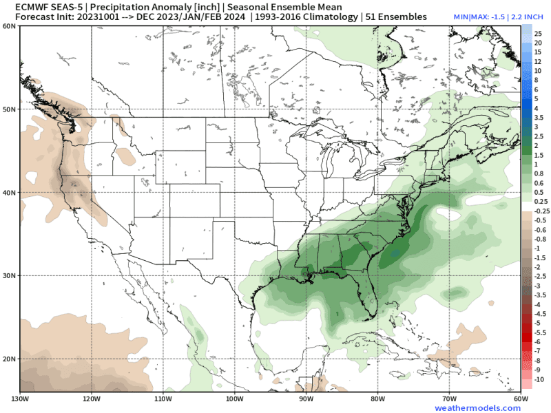
European Model Forecast
Many meteorologists think the European forecast models are superior to the US-based forecast models. The extended outlook for December through February is for below-average precipitation, as indicated in the map below. The outlook also calls for above-average temperatures for the Pacific Northwest.
Given lower precipitation, is drought a concern?
Given the recent moderate rainfall so far in October, discussing drought might seem odd. However, the major wine regions of Oregon and Washington are currently in various stages of drought, as the maps below indicate.
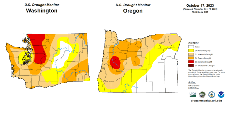
Drought classifications involve many complicated calculations. Much of Washington and Oregon have recently been in drought classification from this dry, warm summer. They will continue to be in this classification even after the recent beneficial rainfall.
Changes in the drought classification depend on some of these metrics taken over several months of data: topsoil moisture, groundwater levels, river basin precipitation, reservoir storage, streamflow, snowpack, temperature and precipitation, and water usage from agriculture. Experts say it takes sustained normal to above normal precipitation to recover water deficits.
The current concern is the winter outlook is for below-normal precipitation and above-average temperatures. If that happens, that would bring a below-average snowpack.
“Less rain/snow pack means that the aquifers are not re-charged to sufficient levels, and many vineyards in the Walla Walla Valley use this well water for their irrigation needs,” says Trey Busch, co-owner and winemaker at Sleight of Hand Cellars in Walla Walla Valley. “We share these same aquifers with wheat farmers, orchards, onions, etc. That can result in a huge drain on our system and something that we need to be paying more attention to here in not just the Walla Walla Valley but eastern Washington overall.”
Conclusions
The El Niño in place right now is currently a strong one, and it likely will be stronger over the next several months. The outlook and past El Niño events suggest that the odds are tilted for the Pacific Northwest to have above-normal temperatures and below-normal precipitation for the period of December through February. This would tend to bring below-average snowpack and potentially bring some concerns for water resources for the spring and summer.
Of course, there are many factors that can change this. We will update as the season progresses.
NOTE: Northwest Wine Report is wholly subscriber funded. The site currently has 70% of the minimum number of paid subscribers needed to be financially viable. Please subscribe to support continued independent content and reviews on this site.
To receive articles via email, click here.


Not enough attention given to the strong negative PDO which is out of phase with El Niño. The effect this winter will likely end up rendering a typical El Niño year not very typical.
I agree Greg. Interesting I just saw recent data that the strong PDO negative phase has diminished some. We will see what happens. Thanks for bringing that up.
Michael