

The following article was written by Michael Fagin. Fagin is an operational meteorologist providing weather forecasts to clients in the Pacific Northwest and providing custom forecast for groups climbing Mt. Everest and other major peaks. Fagin is also a travel writer with a focus on weather and wine.
The Pacific Northwest saw eventful winter and early spring weather. Here, we review what the original forecasts were for these seasons, how well the models did, and briefly review what the forecast models are suggesting for the rest of spring and early summer.
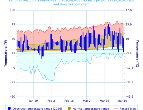
Temperature
There was a La Niña phase in place this past winter. That means sea surface temperatures are below normal off the equatorial waters of South America.
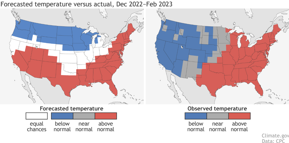
When this pattern is in place, the winter forecast for Washington and Oregon is usually below-normal temperatures and above-normal precipitation. The forecast from the Climate Prediction Center (NOAA) for Washington and Oregon indeed predicted below-normal temperatures and above-normal precipitation for December 2022 through February 2023.
What actually happened?
The forecast for below-normal temperatures was accurate. The map below on the left shows the temperature forecast and the map on the right shows the actual temperature.
Precipitation
In terms of precipitation, the models did not do as well. The map below on the left shows the forecast of above-normal precipitation, and the map on the right shows the actual precipitation. Washington and Oregon both had below-average precipitation during this period.
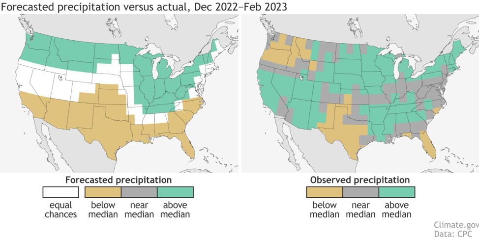
Why was the precipitation forecast off?
We all saw that California had record-breaking precipitation this winter, with numerous moisture-laden weather systems that delivered heavy rain and mountain snow. These systems are called Atmospheric Rivers. (They were previously called Pineapple Express.)
The main reason California was so wet this winter and Oregon and Washington were drier than normal was because a trough of low pressure that was anchored off the California Coast. This trough resulted in wet weather systems being steered into California. It also meant that Washington and Oregon had cooler conditions and below-normal precipitation through February.
Snowpack
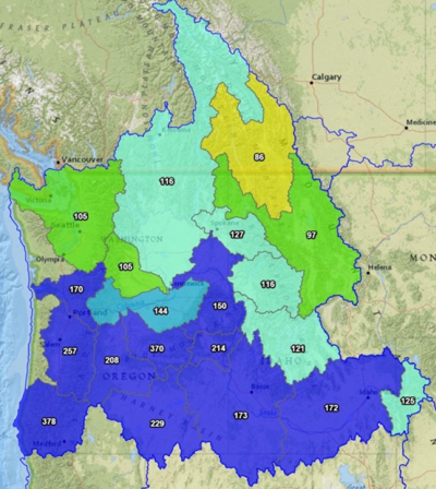
Many were concerned about the potential effects of below-normal precipitation on snowpack, as it is the source of much of the area’s irrigation water in the summer. However, this didn’t turn out as expected.
The map below shows the snowpack for Washington and Oregon as of April 21st, with the numbers representing percent of normal. Much of the Columbia Basin is 116 to 121% above historical averages, while the Willamette Valley is close to 170% above average.
This begs the question, why was the snowpack above average while precipitation was below for much of the period? One of the main reasons is that below-average temperatures kept the snow from melting out, resulting in a larger than expected snowpack.
Recent trends
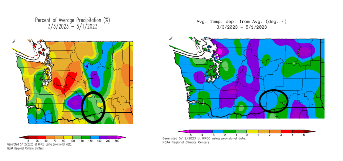
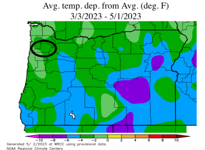
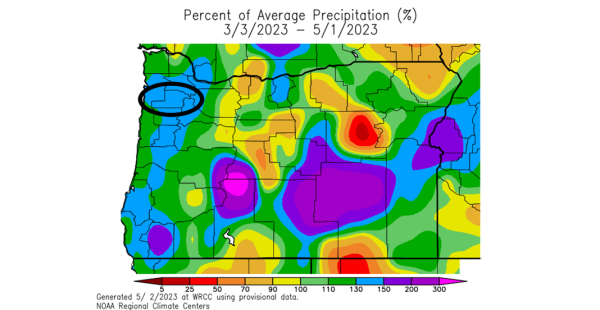
While overall winter precipitation was down, for the last 60 days precipitation has been above average for much of the Columbia Basin. The map below shows Benton County, where the Red Mountain appellation is located, circled in black. The map shows this area in green, which represents 100 to 110% of average precipitation.
Temperatures, meanwhile, were below average for the 60-day period ending May 1st. For Benton County specifically, temperatures were between two to three degrees Fahrenheit below normal.
 What about Willamette Valley? Let’s look at McMinnville, which is located in Yamhill County, circled in black on the map below. The temperatures in green indicate the area continues to be two to four degrees below normal.
Precipitation, meanwhile, has been 130 to 150% above normal for Yamhill County (blue colors in the map ). So overall, we have had a wet, cool start to spring in the Pacific Northwest.
Extended Seasonal Outlook
With cooler temperatures delaying bud break in many areas, what is the outlook for the rest of May and into early summer? First, it must be said that longer-term forecasts are harder to predict. Such seasonal forecasts are certainly subject to errors.
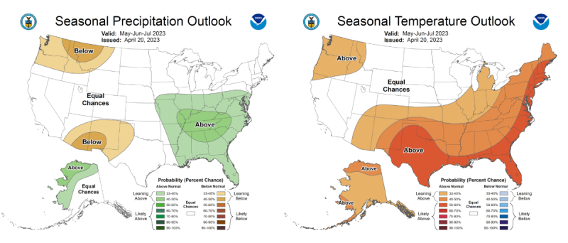
The Climate Prediction Center (NOAA) is forecasting above-normal temperatures and below-normal precipitation for the period of May-June-July. (See the maps below.) For the middle of May, we are seeing a strong ridge of high-pressure building, which tends to bring dry and warm conditions during that period.
In terms of temperatures for June and especially July, it is hard to argue with an above-normal temperatures forecast. That seems to be the trend in recent years. Precipitation is generally less of a factor for June and especially for July, since the Pacific Northwest averages little precipitation during this period.
Summary
In conclusion, it was a cool winter that was drier than forecast, but still with an above average snowpack. Cooler temperatures have persisted into spring, with above average precipitation.
The Climate Prediction Center forecast of above normal temperatures later in spring into the start of summer seems a reasonable and likely outcome. The West Coast historically has a strong ridge of high pressure that is anchored over the region during this time. There is no reason to think this will not be the case this year, bringing warm and dry conditions.
The larger question is whether the the Pacific Northwest will have some extreme heat events that defined the summer of 2021. However, it is, as of yet, too early to forecast.


Leave A Comment