

The following article was written by Michael Fagin. Fagin is an operational meteorologist providing weather forecasts to clients in the Pacific Northwest and providing custom forecast for groups climbing Mt. Everest and other major peaks. Fagin is also a travel writer with a focus on weather and wine.
Lower snowpack and potential summer water issues forecast
Much of the Pacific Northwest is currently in the grips of cold conditions, and the Cascades are getting abundant snowfall. This new snowfall is much needed after a warm, dry start to winter, which was predicted due to the current El Niño conditions.
A look at El Niño conditions
As noted in our last article, El Niño is above average sea surface temperatures off the equatorial waters of South America. In contrast, La Niña is below average sea surface temperatures off the equatorial waters of South America.
In October, the sea surface temperatures were close to 1.5 degrees Celsius above average, and they have now warmed up to close to 2 degrees Celsius above average. This classifies this season as a strong to a very strong El Niño.
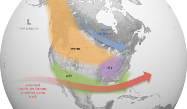
When there is an El Niño in place, the main part of the storm track and resulting precipitation are typically aimed at California, as shown in the graphic below. The net result is the Pacific Northwest has above-average temperatures. With the warmer temperatures, we generally can anticipate below-average mountain snowpack as well. Is this how it has played out thus far?
December 2023 summary
Temperatures
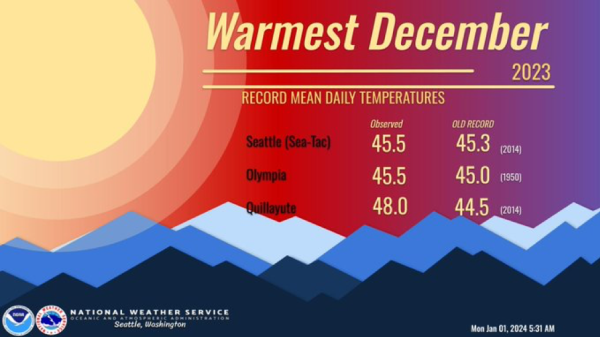
We did indeed have warmer than average temperatures in December. In fact, as the graphic below reflects, some new daily high temperature records were set in areas of Western Washington.
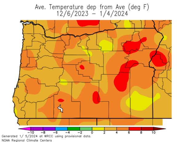
Looking at Pacific Northwest wine country, for much of December, Willamette Valley had 2 to 4 degrees Fahrenheit above average temperatures as reflected in the graphic below.
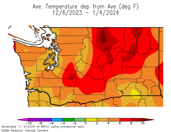
Columbia Basin temperatures, meanwhile, were 2 to 4 degrees Fahrenheit above average, as shown below. However, the yellow colors in areas near Walla Walla were only 0 to 2 degrees Fahrenheit above average.
Precipitation
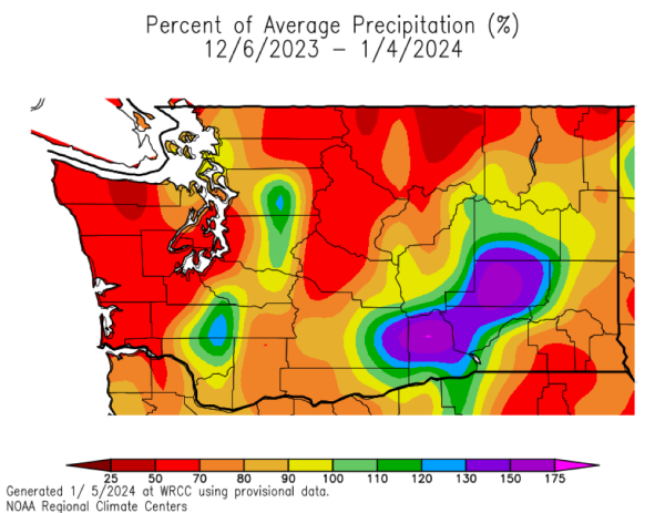
Willamette Valley precipitation was 50 to 70% of average for northern parts of the valley, as shown in the orange colors in the graphic below. The southern parts of the Willamette Valley and into Southern Oregon, shown in red colors, indicate 50 to 70% of average.
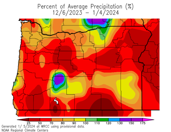
The Columbia Basin has many areas below average, as shown in the red and orange colors in the graphic below. However, there were pockets of blue and purple, which reflects 120 to 150% of average precipitation. These areas include vineyards in east Yakima County, all of Benton County, and parts of Franklin County.
Snowpack
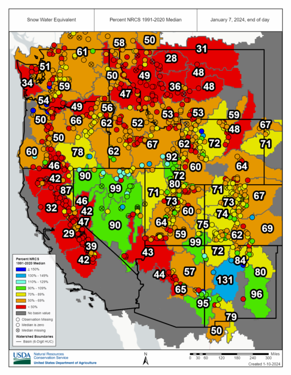
Snowpack is important to monitor, since it provides much of the Pacific Northwest’s summer irrigation needs. The graphic below shows that much of Washington and Oregon have below-average snowpack as of January 7, 2024. Much of Washington and Oregon are close to 50% of average. The burnt orange/brown colors shown below represent from 50 to 67% of average. (The graphic is from NOAA the National Integrated Drought Information Systems.)
Drought
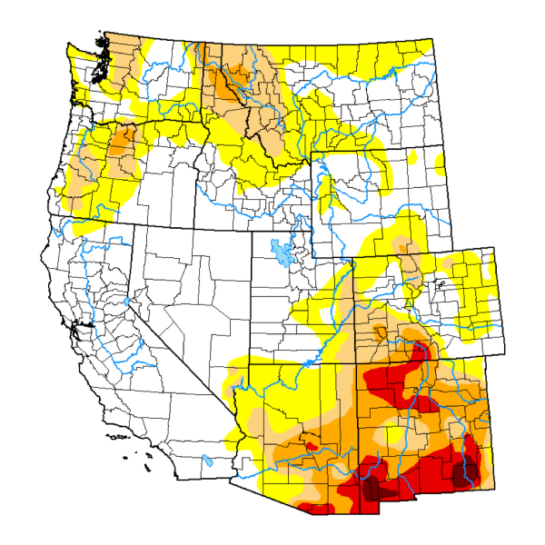
The graphic below is from the US Drought Monitor and shows conditions on January 2, 2024. Most of the Willamette and Columbia valleys are abnormally dry, as indicated by the yellow colors. However, southern parts of the Willamette Valley are in moderate drought, as indicated by the light brown colors.
There is good news, however. Despite the dry December, with the wet fall the Pacific Northwest had, there has been some improvement in the drought conditions over the last several months.
In summary, December saw what often occurs in the Pacific Northwest during a typical El Niño, warm conditions and below-average snowpack. Let us now take a look at the current picture and what the extended forecast indicates.
Short-term outlook
A very cold air mass will be in place over the Pacific Northwest through Tuesday, January 16th. Over the weekend, many areas in the Columbia Basin can expect morning temperatures in the single digits. A few models suggest that some areas can even dip to close to 0. It should be dry through Monday in the Columbia Basin.
Tuesday through Friday in the Columbia Basin we can expect a slow warming trend. Precipitation will be limited with a chance on Tuesday and early Wednesday, and this can be a wintry mix of snow/freezing rain for Tuesday. Then for most of Wednesday all of Thursday and Friday it should be dry with more seasonable temperatures.
For the Willamette Valley, we can expect a wintry mix of snow/freezing rain on Saturday. Then dry conditions for Sunday and Monday with daytime temperatures below freezing and nighttime temperatures in the teens. Tuesday through Friday will bring slowly warming temperatures in the Willamette Valley and increase the chances of light precipitation.
Extended outlook
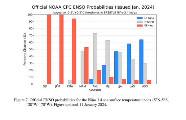
NOAA updated its outlook on January 11, 2024. El Niño is currently strong to very strong, and the outlook is for it to very slowly weaken as we move into the spring. (In the chart below, MAM is March-April-May.)
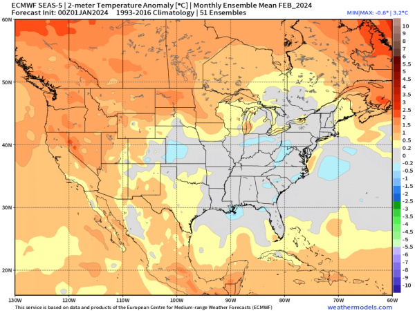
The graphic below is a seasonal forecast issued for February from the European Centre for Medium-Range Weather Forecast (ECMWF). This indicates much of Washington and Oregon will be close to 1 to 1.5 Celsius (1.8 degrees to 2.7 Fahrenheit) above average. This trend is forecast to continue through April.
Will there be drought concerns this spring and summer?
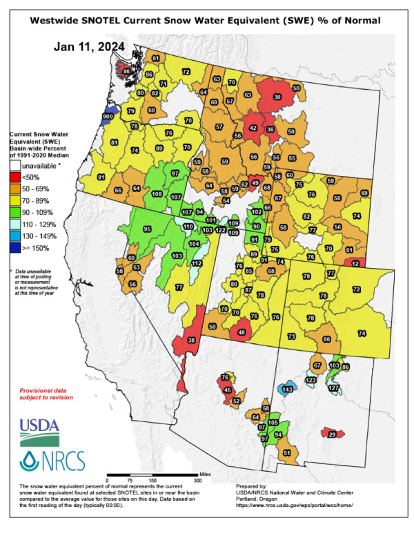
With El Niño expected to continue strong, we can expect above average temperatures for the rest of the winter. This would likely result in a lower snowpack. The current snowpack has improved since the first of the year, with most areas in yellow indicating 70 to 89% of average.
With most winter outlooks suggesting that we will return to warmer conditions likely resulting in a lower snowpack for the rest of the winter, one concern is, how low will the snowpack go? At present, it is too early to say. If it is at or below 50% of average, this would tend to present drought issues as we move into spring.
We will continue to monitor and update on the situation later this winter.
Northwest Wine Report is wholly subscriber funded. Please subscribe to support continued independent content and reviews on this site.
To receive articles via email, click here.


Leave A Comment