The following article was written by Michael Fagin. Fagin is an operational meteorologist providing weather forecasts to clients in the Pacific Northwest and providing custom forecast for groups climbing Mt. Everest and other major peaks. Michael is also a travel writer with a focus on weather and wine.
As the growing season started in Washington, areas of low pressure moved in and out of the region in April and May. The net result was far below average temperatures and above normal precipitation.
The rainfall and additional mountain snowpack were certainly welcome. However, the cold spring was less so. Fortunately, warm and dry conditions returned in July. Growers are hoping for these conditions to continue for the remainder of the growing season.
April and May weather patterns
April started off with a cold bang for the Pacific Northwest. Much of Eastern Washington had close to 5 degrees (F) below average temperatures. The map below shows the parts of Eastern Washington that were 4 to 6 degrees below average temperature (in the blue color, credit Western Regional Climate Center).
But it wasn’t just cold. It was wet.
The map below on the left shows much of Eastern Washington for April 1st to May 8th, 2022 was markedly wetter than historical averages (in dark blue, credit Western Regional Climate Center). In many cases precipitation was 130% to 150% above average. The map on the right shows the precipitation departure from average in inches.
What caused these conditions? The main culprit was a broad trough of low pressure that was anchored over the Northwest for much of April and parts of May. This pattern tends to steer wet and cold weather systems into Washington.
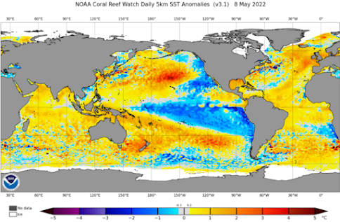
Also, we had La Niña conditions that persisted through the spring. Simply explained, La Niña is below normal sea surface temperature anomalies off the equatorial waters of South America. This pattern usually brings below normal temperatures and above normal precipitation for much of Washington.
The map below shows the cool waters off the coasts of South America and Western US (in blue, credit NOAA). In fact, La Niña strengthened this past April. Several meteorologists have suggested that this contributed to the cooler temperatures for Washington.
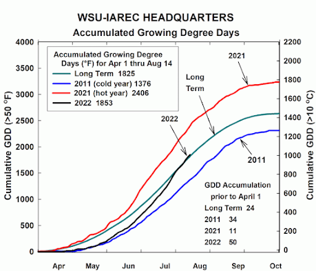
Given the cold wet start to the growing season, it is no surprise that Growing Degree Days (GDD) in the Columbia Valley were below normal during the spring and early summer (GDD is a measure if heat accumulation; it is the average temperatures over 50 from April 1st to October 31st). You can see from this Washington State University GDD graph that 2022 started well below the long-term average before slowly moving up toward it.
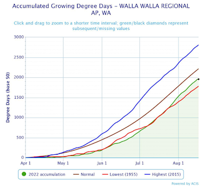
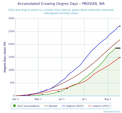
Focusing on two regions with readily available data, Walla Walla and Prosser, we see similar trends. The GDD for 2022 is the green line shown below (charts below from Applied Climate Information System ACIS- NOAA). For both regions, you can see through mid-July, the line is close or equal to the red line, which represents the lowest GDD that occurred in 1955. As the season progressed, warmer temperatures moved Growing Degree Days closer to historical averages. Here, the long-term average is shown as the brown line.
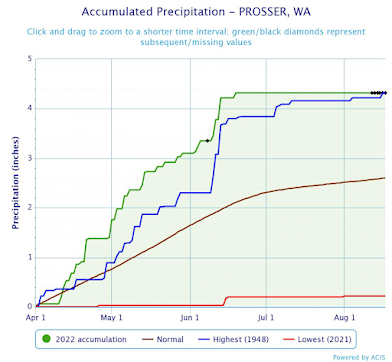
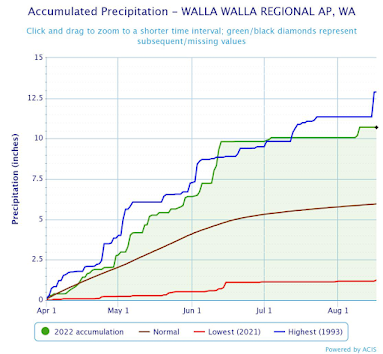
The rainfall chart below for Walla Walla indicates that current precipitation (the green line) was close to the wettest period on record (the blue line) from April to July. Prosser has a similar trend. However it was wetter than the wettest period on record.
Warmer summer temperatures arrive
While the 2022 growing season started out cool and wet, warmer weather in July through mid-August moved Growing Degree Days closer toward the long-term average.
In July, Prosser’s average temperature was 3 degrees above normal. Through August 18th, it is 1.8 degrees above normal. For Walla Walla, July was 1.3 degrees above normal, and through August 18th it is 1.8 above normal.
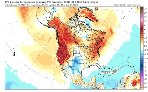
Will the recent warm pattern continue for the rest of August? Several forecast models suggest well above normal temperatures for the remainder of the month. The map below shows expected temperatures from August 18th to September 1st will be 7.2F (4C) warmer than average (credit to Tropical Tidbits).
As noted recently, many growers currently report being approximately two weeks behind recent years in terms of development. It will be interesting to see during the rest of the growing season if this warming trend continues and if GDD can approach closer to the long-term average.
Many are also wondering what September might look like. This is more difficult to say. The extended temperature forecast out to 14 days generally can be accurate. However forecast out to 30 days are less so.
For these extended 30 day outlooks, many meteorologists look at the Climate Forecast System (CFS), which is data from NOAA. At present, the outlook for much of September is temperatures will generally be above normal.
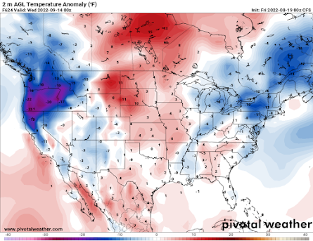
However, there are several cooler air masses that will briefly move for cooler temperatures. The map below indicates below normal temperatures for September 14th (from Pivotal Weather; 2 meter AGL is temperatures 6.6 feet above ground level).
In this case, temperature in dark blue is forecast to be 10 degrees below normal. However, according to the CFS forecast, this cooler system should be short lived.
In truth, only time will tell exactly what September holds.




Leave A Comment